![](/images/other/stat-length.png)
![Randonnée A pied Wetter (Ruhr) - Harkortberg Rundweg A1 - Photo](https://media.geolcdn.com/t/1900/400/ext.pjpeg?maxdim=2&url=https%3A%2F%2Fmedia.geolcdn.com%2Ff%2F726cb39b-5cbe-4b68-b43e-a3bcd858a524.jpeg)
Harkortberg Rundweg A1
SityTrail - itinéraires balisés pédestres
Tous les sentiers balisés d’Europe PRO
![Longueur](/images/other/stat-length.png)
Longueur
3,2 km
![Altitude max](https://static1.geolcdn.com/siteimages/upload/files/1508320355ic_sort_altitude_max_24dp.png)
Altitude max
283 m
![Dénivelé positif](https://static1.geolcdn.com/siteimages/upload/files/1508320355ic_sort_den_pos_24dp.png)
Dénivelé positif
87 m
![Km-Effort](/images/other/stat-length.png)
Km-Effort
4,2 km
![Altitude min](https://static1.geolcdn.com/siteimages/upload/files/1508320355ic_sort_altitude_min_24dp.png)
Altitude min
215 m
![Dénivelé négatif](https://static1.geolcdn.com/siteimages/upload/files/1508320355ic_sort_den_neg_24dp.png)
Dénivelé négatif
32 m
![Boucle](https://static1.geolcdn.com/siteimages/upload/files/16400158638029165_repeat_loop_refresh_sync_direction_icon.png)
Boucle
Non
Balise
Date de création :
2022-02-11 13:40:00.605
Dernière modification :
2022-02-11 13:40:00.605
![A pied](https://static1.geolcdn.com/sitytour/trail-icons/100.png)
57m
Difficulté : Facile
![Scannez ce code QR pour ouvrir la randonnée dans l'application SityTrail](https://capi.geolives.com/qq0zvz2zws4bq2lad0pu/sitytour/trails/3090850/qr.png?size=200)
Application GPS de randonnée GRATUITE
À propos
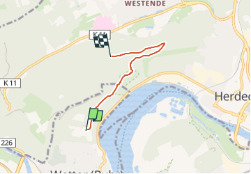
Randonnée A pied de 3,2 km à découvrir à Rhénanie-du-Nord-Westphalie, Ennepe-Ruhr-Kreis, Wetter (Ruhr). Cette randonnée est proposée par SityTrail - itinéraires balisés pédestres.
Description
Randonnée créée par Sauerländischer Gebirgsverein Bezirk Dortmund Ardey.
Localisation
Pays :
Allemagne
Région :
Rhénanie-du-Nord-Westphalie
Département/Province :
Ennepe-Ruhr-Kreis
Commune :
Wetter (Ruhr)
Localité :
Unknown
Départ:(Dec)
Départ:(UTM)
388330 ; 5694947 (32U) N.
Commentaires
Randonnées à proximité
![Randonnée A pied Witten - [Δ] Witten - Grundschöttel - Photo](https://media.geolcdn.com/t/375/260/ext.jpg?maxdim=2&url=https%3A%2F%2Fmedia.geolcdn.com%2Ff%2F2e64de42-6724-4fef-8c50-11bf465b833c.jpeg)
![A pied A pied](https://static1.geolcdn.com/sitytour/trail-icons/100.png)
[Δ] Witten - Grundschöttel
A pied
Moyen
Witten,
Rhénanie-du-Nord-Westphalie,
Ennepe-Ruhr-Kreis,
Allemagne
![](/images/other/stat-length.png)
18 km | 23 km-effort
5h 15min
![](https://static1.geolcdn.com/siteimages/upload/files/16400158638029165_repeat_loop_refresh_sync_direction_icon.png)
Non
![Randonnée A pied Herdecke - [H6] Waldgebiete - Photo](https://media.geolcdn.com/t/375/260/ext.jpg?maxdim=2&url=https%3A%2F%2Fmedia.geolcdn.com%2Ff%2Ffc184e54-a300-4080-bfb1-ee5af7544b8a.jpeg)
![A pied A pied](https://static1.geolcdn.com/sitytour/trail-icons/100.png)
[H6] Waldgebiete
A pied
Moyen
Herdecke,
Rhénanie-du-Nord-Westphalie,
Ennepe-Ruhr-Kreis,
Allemagne
![](/images/other/stat-length.png)
22 km | 29 km-effort
6h 34min
![](https://static1.geolcdn.com/siteimages/upload/files/16400158638029165_repeat_loop_refresh_sync_direction_icon.png)
Oui
![Randonnée A pied Herdecke - [H5] Westende - Kirchende - Ostende - Photo](https://media.geolcdn.com/t/375/260/ext.jpg?maxdim=2&url=https%3A%2F%2Fmedia.geolcdn.com%2Ff%2Fa4190d68-4b9d-4b0c-86e3-91419be4a223.jpeg)
![A pied A pied](https://static1.geolcdn.com/sitytour/trail-icons/100.png)
[H5] Westende - Kirchende - Ostende
A pied
Moyen
Herdecke,
Rhénanie-du-Nord-Westphalie,
Ennepe-Ruhr-Kreis,
Allemagne
![](/images/other/stat-length.png)
17,7 km | 24 km-effort
5h 25min
![](https://static1.geolcdn.com/siteimages/upload/files/16400158638029165_repeat_loop_refresh_sync_direction_icon.png)
Oui
![Randonnée A pied Herdecke - [H3] Hengsteysee und Teufelskanzel - Photo](https://media.geolcdn.com/t/375/260/ext.jpg?maxdim=2&url=https%3A%2F%2Fmedia.geolcdn.com%2Ff%2F48a0ef8e-3704-4b57-a4cf-02a57ebc2595.jpeg)
![A pied A pied](https://static1.geolcdn.com/sitytour/trail-icons/100.png)
[H3] Hengsteysee und Teufelskanzel
A pied
Facile
Herdecke,
Rhénanie-du-Nord-Westphalie,
Ennepe-Ruhr-Kreis,
Allemagne
![](/images/other/stat-length.png)
6,7 km | 9,1 km-effort
2h 3min
![](https://static1.geolcdn.com/siteimages/upload/files/16400158638029165_repeat_loop_refresh_sync_direction_icon.png)
Non
![Randonnée A pied Herdecke - [H2] Ruhrtal zum Hickenstein - Photo](https://media.geolcdn.com/t/375/260/ext.jpg?maxdim=2&url=https%3A%2F%2Fmedia.geolcdn.com%2Ff%2F47dfa9a4-572d-4f34-b111-ae10e112c377.jpeg)
![A pied A pied](https://static1.geolcdn.com/sitytour/trail-icons/100.png)
[H2] Ruhrtal zum Hickenstein
A pied
Facile
Herdecke,
Rhénanie-du-Nord-Westphalie,
Ennepe-Ruhr-Kreis,
Allemagne
![](/images/other/stat-length.png)
8,4 km | 12,2 km-effort
2h 45min
![](https://static1.geolcdn.com/siteimages/upload/files/16400158638029165_repeat_loop_refresh_sync_direction_icon.png)
Oui
![Randonnée A pied Herdecke - [H1] Viadukt und Nacken - Photo](https://media.geolcdn.com/t/375/260/ext.jpg?maxdim=2&url=https%3A%2F%2Fmedia.geolcdn.com%2Ff%2F0816fcff-a194-4a3a-b211-f59c276124fc.jpeg)
![A pied A pied](https://static1.geolcdn.com/sitytour/trail-icons/100.png)
[H1] Viadukt und Nacken
A pied
Facile
Herdecke,
Rhénanie-du-Nord-Westphalie,
Ennepe-Ruhr-Kreis,
Allemagne
![](/images/other/stat-length.png)
5,3 km | 7,6 km-effort
1h 43min
![](https://static1.geolcdn.com/siteimages/upload/files/16400158638029165_repeat_loop_refresh_sync_direction_icon.png)
Oui
![Randonnée A pied Inconnu - Rundwege Hagen 3TürmeWEG - Photo](https://media.geolcdn.com/t/375/260/ext.jpg?maxdim=2&url=https%3A%2F%2Fmedia.geolcdn.com%2Ff%2F836594e2-4f78-4366-a0e0-33994641110a.jpeg)
![A pied A pied](https://static1.geolcdn.com/sitytour/trail-icons/100.png)
Rundwege Hagen 3TürmeWEG
A pied
Facile
Inconnu,
Rhénanie-du-Nord-Westphalie,
Hagen,
Allemagne
![](/images/other/stat-length.png)
11 km | 15 km-effort
3h 25min
![](https://static1.geolcdn.com/siteimages/upload/files/16400158638029165_repeat_loop_refresh_sync_direction_icon.png)
Oui
![Randonnée A pied Gevelsberg - [A3] historischer Rundwanderweg Silschede - Photo](https://media.geolcdn.com/t/375/260/ext.jpg?maxdim=2&url=https%3A%2F%2Fmedia.geolcdn.com%2Ff%2Fe8511c04-2680-4359-a7af-e8f515133e2a.jpeg)
![A pied A pied](https://static1.geolcdn.com/sitytour/trail-icons/100.png)
[A3] historischer Rundwanderweg Silschede
A pied
Facile
Gevelsberg,
Rhénanie-du-Nord-Westphalie,
Ennepe-Ruhr-Kreis,
Allemagne
![](/images/other/stat-length.png)
4 km | 5,3 km-effort
1h 12min
![](https://static1.geolcdn.com/siteimages/upload/files/16400158638029165_repeat_loop_refresh_sync_direction_icon.png)
Oui
![Randonnée A pied Gevelsberg - [A2] Rundwanderweg Silschede - Photo](https://media.geolcdn.com/t/375/260/ext.jpg?maxdim=2&url=https%3A%2F%2Fmedia.geolcdn.com%2Ff%2Fe8511c04-2680-4359-a7af-e8f515133e2a.jpeg)
![A pied A pied](https://static1.geolcdn.com/sitytour/trail-icons/100.png)
[A2] Rundwanderweg Silschede
A pied
Facile
Gevelsberg,
Rhénanie-du-Nord-Westphalie,
Ennepe-Ruhr-Kreis,
Allemagne
![](/images/other/stat-length.png)
7,1 km | 9 km-effort
2h 2min
![](https://static1.geolcdn.com/siteimages/upload/files/16400158638029165_repeat_loop_refresh_sync_direction_icon.png)
Oui